
This guide has been written for the use of members of the general public who are interested in the landscape and underlying geology when walking.
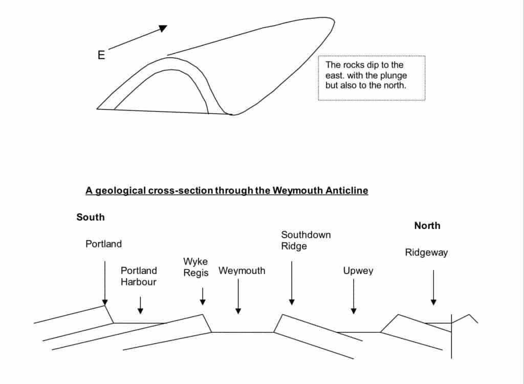
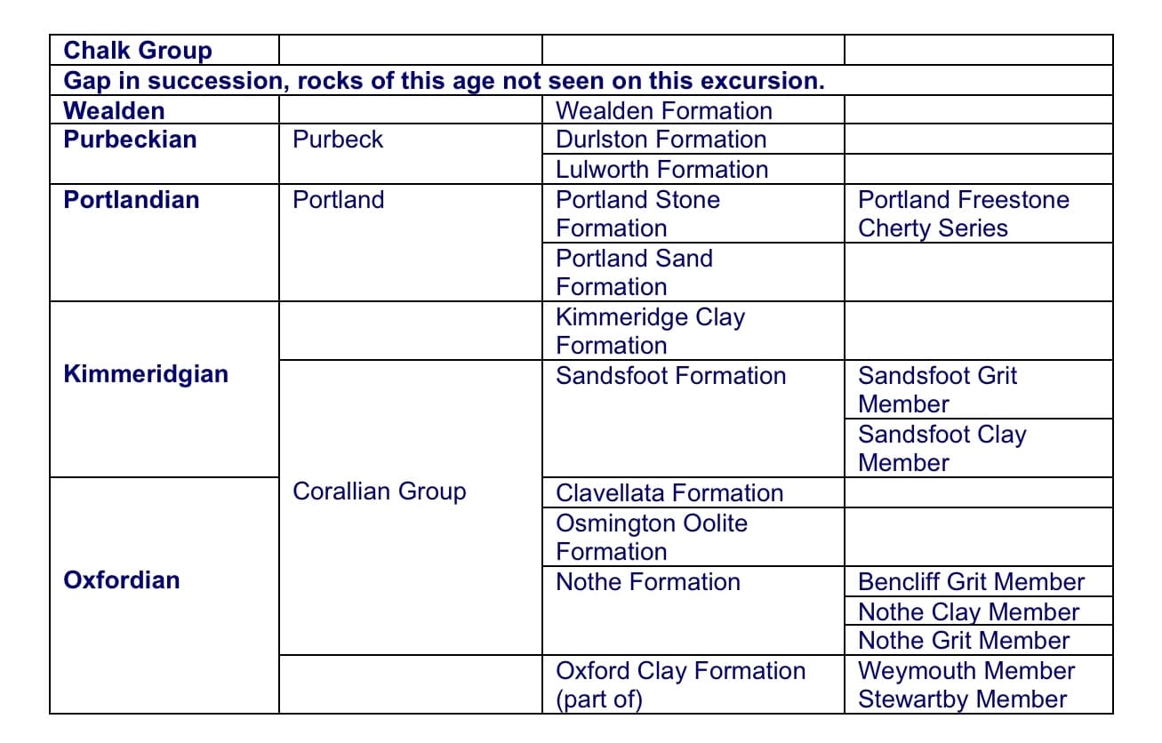
This walk crosses the northern side (limb) of the Weymouth Anticline, a dome shaped fold which extends across south Dorset (Weyland – the area south of the Ridgeway). This Alpine structure (formed during the earth movements associated with the Alpine mountain building period which climaxed 20-30 million years ago) closes and therefore plunges to the east. To the east of Weymouth the oldest rock seen is the Oxford Clay although further west in the centre (core) of the anticline Frome Clay (or Fullers Earth) is exposed around Langton Herring.
As you walk northward towards Upwey you walk with the dip of the strata (rock layers) onto progressively younger rocks. There are also features demonstrating some aspects of engineering geology.
The geological succession seen while walking the Relief Road.
Starting at the junction of Greenway Road and Dorchester Road by the Morrison’s roundabout (GR SY 672818), the bridle-way goes east towards Two Mile Copse. At the start of the walk there are two blocks of Corallian carbonate rich sandstone (probably Bencliff Grit) which have been placed there during construction of the new road. The blocks include some carbonaceous material (black plant debris) and may also show some ripple mark features. Next to the path is crushed Carboniferous Limestone (probably imported from the Mendips) covering the Oxford Clay.
Following the bridleway under the rail bridge (a Victorian structure, the railway reached Weymouth in 1857), which is made of Portland Stone, there is evidence of tufa deposits (a form of limestone laid down by dripping water) including some stalagmites and stalactites on the surface due to seepage from above (possibly drainage through from the railway line ballast which again is probably Carboniferous Limestone). Reaching the Relief Road bridge, which is made of man-made facing stone (unfortunately!), views to the east beyond the tunnel are impaired by the park and ride so the coast is not visible. However there are distant views of the Southdown Ridge (Corallian) which you see later as it cuts the Relief Road south of Littlemoor.
Following the cycleway north parallel with the Relief Road there is little evidence of the underlying geology at this point but there is gently undulating land developed on the Oxford Clay Formation (Stewartby and Weymouth Members equivalent to lamberti, mariae and cordatum ammonite zones). Plateau Gravels (probably of Pleistocene age) rest on the clay to the west (Redlands and Wey Valley School sports fields – possibly benefiting from better drainage). (The Oxford Clay horizons mentioned above are best seen at Furzy Cliff, Preston and along the Fleet from Tidmoor Point southwards.) The flatness and low lying nature of the Oxford Clay Formation is emphasised by the height of the Southdown Ridge to the east. The clay is a weak impermeable rock and is easily eroded away. There is sheet piling along the railway embankment to keep the slope stable.
From the Lorton Lane bridge over the Relief Road, there are views to the south over the Weymouth Anticline across Lodmoor and SW to Wyke Regis and Portland in the distance. Problems of drainage on the impermeable Oxford Clay Formation are emphasised by drainage channels in the cutting to the north of the Lorton Lane bridge. Crushed Portland Stone from the Cherty Beds has been used. This is where the Plateau Gravels outcrop finishes.
Moving further north there is a marked change in colour with sandy material from the base of the Corallian Group being exposed. This is the Nothe Formation (Nothe Grit Formation (including the Preston Grit Member) and Nothe Clay Formation) and very similar to the material that outcrops at the base of the Corallian Group at the eastern end of Furzy Cliff. The colour then changes to darker brown of the Nothe Clay. Gulleying has taken place on the clay surface emphasising its impermeable nature. Drainage is again apparent on the east side of the road with crushed aggregate filling the drainage trenches. On the cutting surface there are loose pieces of limestone and sandstone with evidence of trace fossils typical of the Corallian. This is followed by another orange coloured band which is likely to be the Bencliff Grit, then more clay. Portland Stone has been placed at the base of the slope to receive any run-off. Pieces of grey nodular sandstone occur scattered on the surface of the slope. One large piece of material found in the past showed evidence of slickensides (grooves caused by one piece of rock moving over another, possibly during faulting) and calcite mineralization. There are also blocks of oolitic limestone from the Osmington Oolite. Oolitic limestone is forming now in shallow marine tropical and sub-tropical locations such as the Caribbean so this gives an idea of the environment in Jurassic times in what we now call Dorset.Fossils can be found including gastropods (snails) and bivalves (‘mussel’ shells).
The footpath up to the bridle-way bridge has many large blocks of fossiliferous limestone with bivalves apparent in the area below the power cables. Fencing has been installed and this has collected slumped material on the upslope side of the fence. Walking south towards the pylon on the crest of the hill there are excellent views to the north over the Kimmeridge Clay valley to the Ridgeway. The east / west structure of the Weymouth Anticline is apparent with clear dip of the strata to the north (measured at 26o). The asymmetry of the fold is apparent with steeper dip to north and very gentle dip to the south seen on Portland (<2o) in the distance from by the electricity pylon. The asymmetry of the fold is because of the maximum pressure coming from the south. See Ian West’s excellent website (link below) for views and geological explanation of the features.
There are good exposures immediately to the north of the bridle-way bridge with a dip and strike section in sandstone and Myophorella (an oyster type of fossils) rich limestone beds. There is also a good sample of oolitic limestone (next to the concrete and sheet piling) but it appears to be a loose block so may be from elsewhere in the section. This is a good example of an oosparite, an oolitic limestone with a crystalline matrix. There is also good evidence of alteration (colour change) along fractures in the rock which has introduced new chemicals during the geological history of the rock.
Moving north towards the Jurassic Roundabout (Littlemoor), the land is lower lying coinciding with the change to the Kimmeridge Clay. A stream (a tributary of the River Wey) can be seen culverted under the road with gabions (stone filled wire bags) protecting the banks from erosion or collapse. The poor drainage produces sticky clay soils and collecting ponds have been constructed near the roundabout.
Large blocks of Bencliff Grit, with typical rounded concretions, have been placed on the road side near the roundabout and become a piece of expensive artwork (cost around £300,000)! These include large blocks of sandstone showing good ripple mark evidence which could be seen until they were put on the stainless steel posts!! The ripple marks provide evidence of the shallow water environment in which the rock was formed.
Continuing on along the footpath and cycleway to the north and to the east of the road a well developed ridge with white patches is obvious. This also shows terracettes due to soil creep on this steep slope. The steepest slope is on Portland Stone and breaks of slope can be picked out where the Kimmeridge Clay changes to Portland Sand and then Portland Stone. On a hill further east there appear to be some strip lynchets (evidence of historic or prehistoric activity by people).
Just north of the lay by there is some interesting limestone aggregate which has abundant shell fragments and what appear to be fossil ostracods (small organisms similar to water fleas) . The source of this material is not obvious but could be from the excavation of the cutting through the Purbeck Stone ridge to the north. Beyond the lay by the road cuts the Portland Stone ridge. There is a large amount of chert rich limestone just before the Upwey turn. Chert is silica rich rock similar to flint and occurs in rocks other than the Chalk.
In the Bincombe cutting there is an excellent section from the top of the Portland Stone through the Purbeck Beds into the Wealden Clay (so crossing the Jurassic Cretaceous boundary at around 145 million years old) although the Purbeck material is the best exposed. Dip and strike sections (at right angles to the dip) are apparent. The large number of different beds emphasises the variable environmental conditions when the Purbeck Beds were deposited in a shallow but very extensive lagoon. The Purbeck sequence straddles the Jurassic Cretaceous boundary with the boundary now taken as being within the Cypris Freestones of the Lower Purbeck (Mupe Member within the Lulworth Formation). The succeeding Ridgeway Member has its type section in the former quarry which is now part of the Bincombe SSSI just to the west of the railway line. The Worbarrow Tout member completes the Lulworth Formation has abundant ripple cross-laminations. The low diversity fauna in the lower part suggests brackish to hypersaline conditions (water evaporated in the sub-tropical conditions causing increase in the saltiness of the water) with greater species diversity towards the top with a low salinity lake environment. Some good examples of symmetric ripples can be found in the loose material at the base of the cutting slope and some in-situ ripples can be seen on the west side of the cutting. These ripples suggest wave action in shallow water existed when the sediment was first deposited.
The succeeding Durlston Formation starts with the Cinder Bed (dominated by the oyster Praeexogyra distorta) which is also exposed in the cutting to the west of the new road.
Following the old road the railway cutting just before the Upwey tunnel is interesting and the complex geology is apparent in the geology map on Ian West’s website (see the reference below). The Ridgeway and Abbotsbury Faults cut the area with up faulted Oxford Clay exposed in the fault slice next to the Wealden! The geological structure in Upwey is complex with small fold structures on the northern limb of the Weymouth anticline
Continuing along the footpath and cycleway we reached the Chalk section after crossing the Ridgeway Fault where the chalky nature of the soil in cultivated fields is apparent. The change to the typical rolling ‘downland’ landscape of the Chalk can be seen to the north.
Various quarries (that in the past supplied stone for buildings in local villages as well as Dorchester) are still present in the Upwey area including one to the west of the new road and this is part of the Bincombe SSSI which can also be visited. A lot of clearance work has been carried out in the last 3 years at this site making it much more accessible. Purbeck beds are well exposed and lower down the hill side (now in a private garden) Portland Stone is also visible.
Return to the starting point can be achieved either by retracing your steps along the relief road or walking down into Upwey on to Dorchester Road where the 10 bus service stops.
Alan Holiday
Useful sources:
Geology of south Dorset and south-east Devon and its World Heritage Coast (new B.G.S. memoir).
http://www.soton.ac.uk/~imw/Ridgeway-Railway-Cutting.htm
PLEASE SUPPORT US FOR JUST £2 A MONTH


